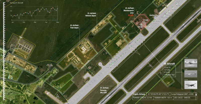
Airbus has joined forces with Earthcube, a French company specialising in the analysis of geospatial data using Artificial Intelligence (AI), to develop and market “Defence Site Monitoring”, an online solution for strategic site monitoring dedicated to defence actors, combining advanced satellite imagery and AI.
The new “Defence Site Monitoring” solution combines Earthcube’s expertise in the automatic identification of objects with high-resolution images from Airbus‘ 50cm Pléiades satellites and from 2021, using even higher-resolution 30cm imagery from its Pleiades Neo constellation. The algorithms used are already capable of automatically detecting, identifying and classifying aircraft and ships, both civil and military.
“Airbus is a strategic partner for French and European Armed Forces, serving national sovereignty and providing reliable and secure intelligence solutions. With ‘Defence Site Monitoring”, hundreds of sites of interest will be monitored and analysed daily, thanks to the reactivity and agility of our satellites and Earthcube’s AI algorithms, capable of processing gigabytes of data.” said François Lombard, Director of Intelligence business at Airbus Defence and Space.
“As the European leader in AI data processing, Earthcube’s mission is to work closely with major industrial players who are able to combine their expertise with the excellence of our technology in a logic of ever-increasing added value. We are very proud of “Defence Site Monitoring” and of this partnership with Airbus, which perfectly illustrates this shared ambition,” said Arnaud Guérin, President and co-founder of Earthcube.
Image Analysts can access Defence Site Monitoring via a fully secure area on the Airbus OneAtlas digital platform. They can monitor their areas of interest and receive automated alerts and trend analysis reports.
Through this collaboration, Airbus and Earthcube are demonstrating true European know-how and a capacity to meet the most demanding needs of the intelligence services and our troops engaged in the various theatres of operation.
If you would like to join our community and read more articles like this then please click here
ai Airbus artificial intelligence Defence Site Monitoring Earthcube


