Case study from Createc who will pitch their ideas to industry and investors at the CDE Marketplace on 6th September 2016.
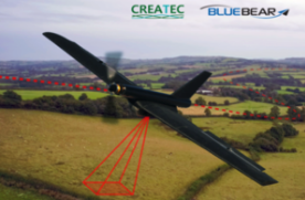
Createc has been funded by the Centre for Defence Enterprise (CDE) to work on a software solution that can be easily incorporated into existing unmanned air systems (UAS) using only on-board passive sensors and a previous map.
The Live Maps: Air project aimed to demonstrate how a small UAS could navigate without global positioning system (GPS) while simultaneously validating and updating untrusted maps. This could add a new capability to the current generation of in-service small UAS.
Createc’s algorithms have been tested and developed using the BlackStart platform developed by Blue Bear Systems Research and the Black Hornet developed by Prox Dynamics and flown by Blue Bear.
The location drift compared to GPS using just the flexible-map algorithm has been demonstrated to be around 10-20%. With the Live Maps: Air algorithms used to correct the trajectory, these error rates reduce to around 1-5%. Because the errors are corrected by reference to a static map, errors don’t increase continuously over time; when distinctive locations are overflown most error that has been accumulated to that point is eliminated.
Beyond this project there are further areas of development which could result in minimal integration costs for existing small UAS platforms to enable them to fly in GPS denied environments.
Dr Matthew Mellor, Managing Director, Createc says: “The CDE funding has enabled Createc to develop technologies for MOD and access a market traditionally very difficult for an SME to enter. In addition this project has enabled Createc to build a good relationship with an established supplier to MOD.”
Createc is a Research and Development consultancy founded in 2010, based in Cockermouth, Cumbria. Createc has 11 employees working on imaging and sensing projects primarily for the civil nuclear and defence markets.
If you would like to join our community and read more articles like this then please click here


